Territorial questions in post-colonial Africa remain a great source of conflict as regards international land and maritime borders. Irredentism, inconsistent and vague colonial maps, as well as lack of prior delimitation or clumsy administrative steps between colonial and independence governments, partly contribute to territorial disputes in Africa today.
Kenya is embroiled in territorial disputes with its neighbors Somalia, South Sudan, Uganda, and Ethiopia. Territorial disputes along Kenya’s western, north-western and south-eastern frontiers can potentially reduce the size of its terrestrial and maritime territory if expansionist or revisionist claims by neighboring states sail through. However, Kenya has not been adequately projecting strong diplomacy and defence for strategic leverage over territorial questions. Thus, Kenya should re-posture herself legislatively, diplomatically, and in defence, to secure her territorial integrity.
Current Territorial Disputes
Somalia is claiming a 100,000 square kilometers of maritime territory in the Indian Ocean from Kenya, as the maritime boundary between the two states remain un-delimited. The maritime triangle is conventionally understood to be under Kenyan sovereignty, at least according to the 1979 Presidential Decree.
On the other hand, South Sudan is claiming over 14,000 square kilometers of territory, the Ilemi Triangle. The Triangle sits indeterminably around the common border between South Sudan, Ethiopia, and Kenya. In 1936, the colonial authorities in Juba allowed the British colonial governor of Kenya, to administer the Triangle. Kenya retained its administration over the territory at Sudan’s independence in 1956, and since South Sudan’s secessionist campaigns, Juba has never lost sight of Ilemi Triangle.
Ethiopia and Kenya had a boundary settlement in 1967, and established their common boundary at Nadapal. However, over the years, Ethiopian forces have breached Kenya’s territorial integrity, and uprooted the beacons at Nadapal. In revising the Nadapal boundary, the Ethiopian forces lay claim four kilometers southwards into the Ilemi Triangle, up to Todonyang, further complicating the question of Ilemi Triangle. Ethiopia’s claim is based on the 1907 Anglo-Ethiopian Treaty and the situation under Abyssinian emperors, Tewodros II and Menelik II, during the partition of Africa (when Ethiopia supposedly had a trade-off with Sudan).
In Lake Victoria, the territory shared among Kenya, Uganda, and Tanzania, presents another territorial question between Kenya by Uganda. Uganda is claiming the 2,000 square meters of territory, the Migingo Island, and started making expressions of sovereign control around 2004. The Island and its surrounding waters have, however, been historically understood to belong to Kenya’s sovereignty.
Kenya’s History of Diplomatic and Defence Strength
Territorial disputes have lived with Kenya’s republican status since early 1960s. As Kenya prepared for its independence from Britain, the Somali community inhabiting the north eastern part of Kenya, the erstwhile North Eastern Province, wanted to secede to Somalia. The leading political leaders at the time, Jomo Kenyatta and Ronald Ngala, opposed this attempt, during the Kenya Constitutional Conference of 1962 at Lancaster House.
When the secessionist movement became militant under the sponsorship of Somalia, the Kenyatta government in Kenya went to war with Somalia between 1963 and 1964. The Organization of African Unity (OAU) did not only broker a ceasefire, but under pressure from governments and pan-Africanists such as Kenyatta, passed Resolution 16 (1) in July 1964 to protect colonial boundaries of African states at their independence. The same year, facing a common territorial threat, Jomo Kenyatta and Emperor Haile Selassie of Ethiopia concluded a defence pact, to protect their national territory from Somali expansionism and irredentism. Mohammed Ibrahim Egal was elected to the Office of the Prime Minister in Somalia in 1967, and in 1968, Somalia, Kenya and Ethiopia, through OAU, amicably restored ties and Somalia abandoned ‘Greater Somalia’ policy.
In 1971, Idi Amin toppled the government of Milton Obote in Uganda and threatened to march militarily into Kenya to ‘reclaim’ parts of Rift Valley and Nyanza, up to Naivasha. After mobilizing solidarity and patriotism among Kenyans, by informing the country of the threat posed by Idi Amin, Kenyatta moved as the commander in chief, to stop the aggression in its tracks. Kenyatta sent the combat-ready military to the border with Uganda and even closed the border with Uganda, which caused acute shortage of commodities in Uganda. Dr. Munyua Waiyaki, the then Minister for Foreign Affairs, conducted shuttle diplomacy across Africa and the OAU, which created pressure on Amin to back down from his militaristic campaign. Uganda’s claims were based on the pre-colonial British understanding of its ‘sphere of influence’ in East Africa, in which the foregoing regions fell under Uganda. It is the British Secretary of State Hebert Asquith, who later aided the transfer ‘regions of Uganda’ to Sudan in 1916, and Kenya in 1926.
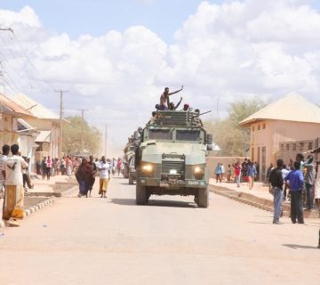
In October 1987, Kenya, under President Daniel Moi, repelled another Ugandan aggression under President Yoweri Museveni. While entangled in counter-insurgency campaigns in the northern and eastern parts of Uganda, which border Kenya, Museveni intended to deploy his military along the border with Kenya as a bulwark. More recently, in 2010, President Mwai Kibaki, sent Kenyan forces into Somalia to defend the country against the expansionist and security threat posed by al Shabab, the main militant group in Somalia.
Current Legislative Gaffes
Concerning current territorial questions facing Kenya, a display of weak legislative, diplomatic and defence posture on the part of Kenya, surround their determination in the country’s historical advantage over the territories in question. Historicallasy, Kenya has administered the Ilemi Triangle, the Migingo Island, and the maritime territory in the Indian Ocean. Colonial maps indicate Migingo being Kenyan, while colonial acts of ceding administration of Ilemi constitute effectivités as well as the establishment of a military post and deployment of the military by Kenya into the Triangle.
Legislatively, the Kenyan parliament is struggling to constitutionally determine the Kenyan territory to preclude any contradicting expansionist claim. The question of the Ilemi Triangle, Migingo Island, and the maritime triangle are silent in the Kenyan law, and parliament is yet to pass an Act in accordance with Article 5 of the Constitution which stipulates that “Kenya consists of the territory and territorial waters comprising Kenya on the effective date, and any additional territory and territorial waters as defined by an Act of Parliament”. The lack of legal framework protecting Kenya’s territory from question, subjects the country’s territorial integrity to political settlements between Kenya and its neighboring states or use of force.
Diplomatic and Defence Flaws
Political settlements are determined by diplomatic strategies. However, if diplomacy fails and territorial questions fall into the realm of force, the latter avails dual utility to further diplomatic ends through coercion and political goals through war. The realm of force is effectively secured and advanced by appropriate and demonstrably powerful defence posturing.
For instance, in 2004, Uganda deployed its military around Migingo Island, with the initial intention of warding of armed pirates preying on Kenyan, Ugandan and Tanzanian fishermen in Lake Victoria. Migingo Island proved strategic to Uganda’s surveillance operations. After the Ugandan security forces had successfully rid the lake of armed pirates in 2004, they instituted taxes in Migingo Island in return for ‘security’. Uganda’s ‘security operation’ and the strategic importance of the Island, stretched Ugandan interests into declaring the ownership of the Island. Subsequently, Ugandan and Kenyan security authorities have scrambled for control over the Island, with Ugandan authorities pulling the Kenyan flag down.
Over the maritime territory in the Indian Ocean, preliminary negotiations in 2009 failed, necessitating judicial recourse at the International Court of Justice in 2014, on the part of Somalia. The court process cannot guarantee neither a negotiable settlement nor a re-negotiable settlement post facto. Kenya is now under a legal trap, with its territorial integrity hanging in the balance of the scales international arbitration, a needless position.
The Joint Boundary Commission set up by then Kenyan president, Mwai Kibaki, Prime Minister Raila Odinga, and Uganda’s President Yoweri Museveni, has not concluded the matter successfully. Various attempts to set up joint security commissions, such as between the Kenya and Uganda police in 2016, have not helped resolve the dispute.
In the Ilemi Triangle, a loosely administered but largely ungoverned territory and competing claims over it, further puts the country’s territorial integrity on test. While Kenya has administered the Triangle since 1936, the Triangle is virtually an ungoverned space. The Triangle is a legendary cattle rustling hub, with communities in the region living by the law of the jungle. The Didinga, Nyangatom and Toposa of South Sudan, the Turkana of Kenya, the Dessanach of Ethiopia, and the Karamajong of Uganda engage in violent conflicts over water and pasture in the area. The ‘Ilemi communities’ have had a history of militia activity, with series of disarmament campaigns failing to rid the Triangle of small arms and light weapons.
Kenya’s Advantage
All of the disputed territories, have been historically administered or fallen under Kenya’s political jurisdiction. The Ilemi Triangle has been administered by Kenya since 1936, the maritime territory in the Indian Ocean being claimed by Somalia has been under Kenya’s sovereignty since 1979. 1926 demarcation maps according to preliminary findings of the 2009 Joint Boundary Commission, allegedly shows Migingo Island lying 500 meters within the Kenyan boundary. Kenyans have been inhabiting the Island since 2004. Kenya has the advantage to strategically deploy diplomatic and defense instruments to change the course of these disputes, and retain its territorial heritage at little political cost.
Therefore, since Kenya’s territorial integrity lies on the thin line between political negotiation and war, Kenya has to display strength, skill and art in its diplomatic and defense posturing, to ably defend its historical advantage, and secure the disputed territories. Effective occupation and control of these disputed territories by Kenya, and clear legislations on Kenya’s territory should be the first important steps to be taken by the Kenyan government as diplomatic efforts remain engaged.
Edmond J. Pamba is a Research Assistant at the HORN Institute.
Photo: Migingo Island in Lake Victoria. The Island has been the source of tension between Kenya and Uganda for a long time (Photo Credit: Jeroen Van Loon/Al Jazeera)